


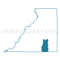
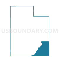
Bluff Voting District, San Juan County, Utah
About
Outline

Summary
| Unique Area Identifier | 679860 |
| Name | Bluff Voting District |
| County | San Juan County |
| State | Utah |
| Area (square miles) | 385.18 |
| Land Area (square miles) | 383.95 |
| Water Area (square miles) | 1.23 |
| % of Land Area | 99.68 |
| % of Water Area | 0.32 |
| Latitude of the Internal Point | 37.19605970 |
| Longtitude of the Internal Point | -109.56838970 |
Maps

Graphs
Select a template below for downloading or customizing gragh for Bluff Voting District, San Juan County, Utah


Neighbors
Neighoring Voting District (by Name) Neighboring Voting District on the Map
- Blanding Southeast Voting District, San Juan County, UT
- Blanding Southwest Voting District, San Juan County, UT
- Dennehotso Voting District, Apache County, AZ
- Mexican Hat Voting District, San Juan County, UT
- Mexican Water Voting District, Apache County, AZ
- Montezuma Creek Voting District, San Juan County, UT
- Red Mesa Voting District, San Juan County, UT
- Red Mesa Voting District, Apache County, AZ
- White Mesa Voting District, San Juan County, UT
Top 10 Neighboring County Subdivision (by Population) Neighboring County Subdivision on the Map
- Sweetwater CCD, Apache County, AZ (5,628)
- Blanding CCD, San Juan County, UT (4,904)
- Casa del Eco Mesa-White Mesa CCD, San Juan County, UT (3,882)
- Oljato CCD, San Juan County, UT (2,187)
- Dennehotso CCD, Apache County, AZ (1,578)
Top 10 Neighboring Place (by Population) Neighboring Place on the Map
Top 10 Neighboring Unified School District (by Population) Neighboring Unified School District on the Map
Top 10 Neighboring State Legislative District Lower Chamber (by Population) Neighboring State Legislative District Lower Chamber on the Map
Top 10 Neighboring State Legislative District Upper Chamber (by Population) Neighboring State Legislative District Upper Chamber on the Map
Top 10 Neighboring 111th Congressional District (by Population) Neighboring 111th Congressional District on the Map
Top 10 Neighboring Census Tract (by Population) Neighboring Census Tract on the Map
- Census Tract 9427, Apache County, AZ (5,628)
- Census Tract 9782, San Juan County, UT (4,904)
- Census Tract 9420, San Juan County, UT (3,882)
- Census Tract 9421, San Juan County, UT (2,187)
- Census Tract 9426, Apache County, AZ (1,578)